
Description
Introduction Plane Table Surveying Instrument
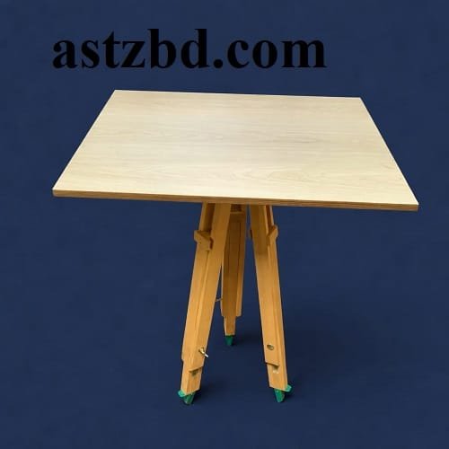
The Plane Table Surveying Instrument delivers one of the most direct and efficient methods of field mapping available to civil engineers and surveyors today. This graphical surveying tool allows the operator to observe ground features and plot them on paper simultaneously, eliminating the need for separate office calculations or data transfer steps. Engineers, students, and land surveyors across Bangladesh use the plane table set for road alignment surveys, topographic mapping, boundary demarcation, and site investigation work. The complete set includes a seasoned wood drawing board (750 mm × 600 mm), a sturdy adjustable tripod, an alidade for sighting, a trough compass, a spirit level, and a plumb bob with plumbing fork — everything a surveyor needs to start productive fieldwork immediately.
Specifications Plane Table Surveying Instrument
| Parameter | Details |
| Instrument Name | Plane Table Surveying Instrument |
| Drawing Board Size | 750 mm × 600 mm (standard0 |
| Board Material | Well-seasoned hardwood (teak or equivalent) |
| Board Surface | Smooth, flat, warping-resistant drawing surface |
| Tripod Material | Seasoned wood (lightweight field-grade) |
| Tripod Leg Length | Approximately 1200 mm (adjustable) |
| Tripod Head Type | Ball-and-socket or leveling screw arrangement |
| Alidade Type | Plain Alidade (standard) / Telescopic Alidade (advanced option) |
| Alidade Material | Brass or gunmetal straight edge, approx. 450 mm long |
| Alidade Edge | Beveled fiducial edge for accurate ray drawing |
| Sight Vanes | Two hinged vanes — eye vane (narrow slit) and object vane (fine thread) |
| Spirit Level | Small circular/tubular bubble level with flat base |
| Trough Compass | Brass trough compass for meridian marking and orientation |
| Plumb Bob & Plumbing Fork | U-shaped brass plumbing fork with attached plumb bob for centering |
| Waterproof Cover | Included for weather protection of drawing sheet |
| Drawing Sheet | High-quality, well-seasoned mapping paper (not pre-printed) |
| Surveying Method Support | Radiation, Traversing, Intersection, Resection |
| Applicable Survey Area | Up to 250 km² (plane surveying assumption) |
| Suitable Terrain | Flat to moderately undulating terrain |
| Standard Compliance | Survey of India Pattern / IS standard configurations available |
Key Features Plane Table Surveying Instrument
- Simultaneous Observation and Plotting: The plane table lets surveyors draw the map directly in the field while taking observations, which eliminates transcription errors and saves office drafting time.
- Well-Seasoned Hardwood Board: The drawing board uses properly seasoned teak or equivalent hardwood, which resists warping and dimensional changes caused by humidity and outdoor temperature fluctuations.
- Precision Alidade Sighting: The brass alidade provides a true fiducial edge for accurate ray drawing. The two hinged sight vanes fold flat for compact transport and deploy firmly for reliable line-of-sight alignment.
- Stable Adjustable Tripod: The tripod features approximately 1200 mm adjustable legs and a ball-and-socket or three-screw leveling head, giving a stable, level platform even on uneven ground.
- Accurate Centering System: The plumbing fork and plumb bob allow the surveyor to align the station point on the paper precisely over the ground mark, which ensures correct spatial referencing of the survey.
- Built-In Spirit Level: The included spirit level tube quickly confirms that the table reaches a true horizontal plane before plotting begins, preventing systematic tilt errors.
- Trough Compass for Orientation: The trough compass marks the magnetic meridian on the drawing sheet at each station, enabling correct orientation of the board and consistent directional plotting across multiple survey stations.
Applications
Topographic Mapping: Survey teams use the plane table to produce contour maps and feature plans for areas up to 250 km², drawing elevation and ground detail directly in the field.
Road and Highway Alignment Surveys: Civil engineers use the instrument to plot preliminary alignment routes for road, highway, and railway projects, marking curves, gradients, and key stations on the drawing sheet.
Boundary and Land Demarcation: Land surveyors employ the plane table to establish and record property boundaries, plot corner stations, and produce cadastral sketches for legal and land administration purposes.
Dam and Reservoir Site Surveys: Project teams use the instrument during pre-feasibility studies for dams, barrages, and irrigation reservoirs to map the catchment area and propose structure locations.
Bridge and Culvert Site Investigation: Engineers apply the traversing and intersection methods of plane table surveying to locate bridge crossing points and measure river widths and bank profiles.
Geological and Soil Mapping: Geologists and soil scientists use the instrument to record rock outcrops, soil type boundaries, and geological features directly onto field maps without transporting data back to an office.
Agricultural Land Survey: Agricultural engineers survey farm plots, irrigation channels, and bund alignments using the plane table, producing working maps suitable for layout and earthwork estimation.
Who Uses This
- Civil Engineering Students at universities, polytechnic institutes, and diploma colleges who complete compulsory surveying practical coursework using the plane table as a core instrument.
- Government Survey Departments including the Survey of Bangladesh, LGED, Roads and Highways Department, and BWDB field teams who conduct topographic and alignment surveys across the country.
- Private Civil Engineering Consultancies that carry out site investigations, road design surveys, and land development feasibility studies for client projects.
- Land Surveyors and Revenue Survey Officials who use the plane table for cadastral surveying, land demarcation, and khasra mapping in rural and peri-urban areas.
- Construction Companies and Contractors who operate preliminary site layout surveys before deploying more expensive total station or GPS equipment.
- Agricultural Engineers working under government and NGO programs who map field plots, irrigation channels, and drainage layouts using graphical field methods.
- Geological Survey Teams from institutions like the Geological Survey of Bangladesh who record field observations and geological boundaries during mapping campaigns.
Frequently Asked Questions (FAQ)
Q1: What does a complete plane table surveying instrument set include? A complete set includes the drawing board (750 mm × 600 mm), adjustable wooden or tripod, plain or telescopic alidade, trough compass, spirit level, plumb bob, plumbing fork, and a waterproof cover. ASTZ supplies the full set ready for immediate fieldwork.
Q2: What is the standard size of the plane table drawing board? The standard field size is 750 mm × 600 mm. Smaller sizes — 400×300 mm, 450×450 mm, and 600×600 mm — also exist for lighter field applications and student use.
Q3: What wood material does the drawing board use? The board uses well-seasoned hardwood, typically teak or a similar stable timber. Proper seasoning prevents warping caused by moisture changes during outdoor use.
Q4: What is the difference between a plain alidade and a telescopic alidade? A plain alidade uses two hinged sight vanes for direction alignment on flat terrain. A telescopic alidade mounts a small telescope and vertical arc on the straight edge, enabling distance measurement by stadia and angle measurement for hilly terrain.
Q5: For how large an area does the plane table survey method work? The plane table method works effectively for surveys up to 250 km², where the curvature of the earth remains negligible and the plane surveying assumption holds valid.
Why Buy from ASTZ?
- Trusted Surveying Equipment Supplier: ASTZ maintains an established reputation as a reliable supplier of professional surveying instruments to government agencies, engineering consultancies, and academic institutions across Bangladesh.
- Complete Sets Ready to Use: ASTZ ships the full plane table set — board, tripod, alidade, compass, spirit level, plumb bob, plumbing fork, and cover — together so buyers start fieldwork immediately after delivery.
- Quality-Verified Instruments: ASTZ sources instruments from quality-controlled manufacturers and inspects every set before dispatch, ensuring the board surface is flat, the alidade edge is true, and the tripod mechanism operates smoothly.
- Expert Technical Guidance: The ASTZ technical team advises customers on instrument selection, proper setup procedures, and survey method selection based on the specific site conditions and project scope.
- Nationwide Delivery: ASTZ delivers to Dhaka, Chittagong, Sylhet, Rajshahi, Khulna, Barisal, Rangpur, Mymensingh, and all districts across Bangladesh efficiently and reliably.
- Competitive and Transparent Pricing: ASTZ offers fair, clearly stated prices with no hidden charges. Bulk orders from institutions and survey teams receive preferential pricing and dedicated account support.
- After-Sales Support: ASTZ provides post-purchase technical support to help customers with assembly, leveling, orientation procedures, and any questions about surveying methods — at no additional cost.



Reviews
There are no reviews yet.